The shipping lanes through the Strait of Hormuz
Every large tanker in the strait uses a corridor about six nautical miles wide. Here is how it is laid out, who set it, and why that narrowness is the strategic fact about the waterway.
| Measure | Figure |
|---|---|
| Inbound lane width | 2 nautical miles (3.7 km) |
| Outbound lane width | 2 nautical miles (3.7 km) |
| Separation zone width | About 2 nautical miles (3.7 km) |
| Total routed corridor | About 6 nautical miles (11 km) |
| Strait width at narrowest | 39 km (21 nautical miles)The routed corridor uses roughly a quarter of it. |
| Location | North of the Musandam Peninsula, Oman |
| Adopted by | The International Maritime Organization |
| Inshore traffic zone | Separate, for smaller local traffic |
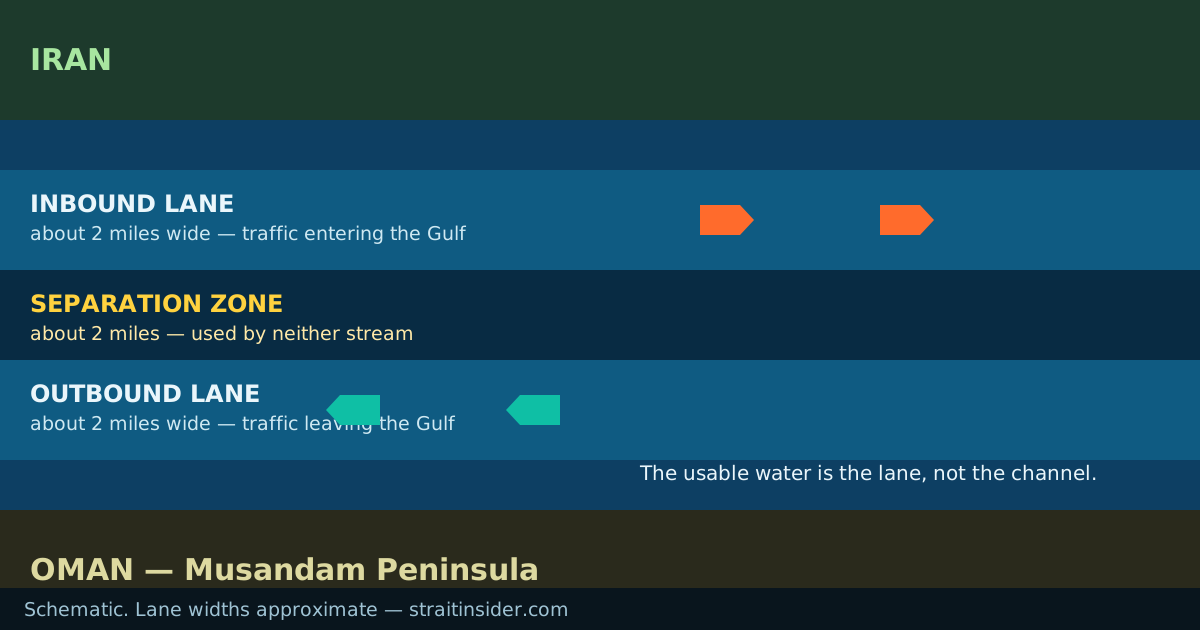
How the scheme is laid out
A traffic separation scheme is the maritime equivalent of a dual carriageway. Rather than letting ships pick their own line through a congested channel, traffic is routed into one-way lanes with a buffer between them, which converts a head-on collision risk into an overtaking one.
In the Strait of Hormuz the scheme runs north of Oman’s Musandam Peninsula. Inbound traffic bound for the Persian Gulf uses one lane; outbound traffic uses the other; and a separation zone sits between them which ships are not to enter except when crossing or in an emergency. Each lane is two nautical miles wide, and the separation zone is about the same, giving a total routed corridor of roughly six nautical miles.
Closer to the coast, an inshore traffic zone is set aside for smaller local traffic — fishing vessels, coastal craft, dhows — which keeps them out of the path of deep-draught ships. The Strauss Center notes that parts of the inshore zone south of Didamar exceed 200 metres in depth, so the separation is about traffic rather than water.
Why the corridor is where it is
Two constraints put it there, and neither is negotiable. The first is depth: the lanes follow water that will float a fully laden very large crude carrier, and the strait is not uniformly deep enough — water shallower than about 25 metres is treated as unsafe for loaded tankers.
The second is the shape of the channel. The strait bends around the Musandam Peninsula, so a routeing scheme has to turn with it. The lanes carry traffic south-east out of the Gulf and then east into the Gulf of Oman, with the turn north of the peninsula.
The consequence is that the route is not relocatable. A master facing a threat in the lanes cannot simply move twenty miles sideways, because the alternative water may be too shallow or may not go anywhere. That inflexibility is the thing to hold on to in any discussion of the strait’s vulnerability.
What gives the scheme authority
Traffic separation schemes are adopted through the International Maritime Organization, which is the UN body responsible for ships’ routeing, and once adopted they are given effect by Rule 10 of the International Regulations for Preventing Collisions at Sea. A ship using a scheme must proceed in the appropriate lane, in the general direction of traffic flow, and keep clear of the separation zone.
This is worth distinguishing from what has been happening since 2026. The routeing measures in the strait are IMO instruments, adopted internationally. The transit authorisation regime Iran has operated since May 2026 is an Iranian national arrangement, and not a recognised one. The two are frequently conflated in coverage: a vessel being directed onto a "designated route" by Iran is not the same thing as a vessel complying with the traffic separation scheme.
The separation zone, and a query it keeps attracting
A separation zone is the buffer between opposing lanes — a defined area of water, not a line. Ships do not navigate along it; they cross it as directly as practicable if they must cross at all.
Separation zones exist in many congested waters, including several in the Indian Ocean approaches and around the Gulf, which is why searches for terms like "separation zone Indian Ocean" lead here. The Hormuz scheme is one instance of a general measure, and if you are after a specific scheme’s boundaries, the IMO’s ships’ routeing publication and the relevant chart are the authoritative place to look rather than any website.
Common questions
- How wide are the shipping lanes in the Strait of Hormuz?
- Two nautical miles — about 3.7 km — in each direction, with a separation zone of about the same width between them, giving a routed corridor of roughly six nautical miles.
- What is a traffic separation zone?
- The buffer area between opposing one-way traffic lanes in a routeing scheme. Ships keep out of it except to cross, and then cross as nearly at right angles to the traffic flow as practicable.
- Are ships required to use the traffic separation scheme?
- Vessels using a scheme must follow Rule 10 of the COLREGs — proceed in the correct lane, in the direction of flow, and keep clear of the separation zone. Deep-draught ships have little practical alternative in any case, because of the depth.
- Who decides where the lanes run?
- Routeing schemes are adopted through the International Maritime Organization. They are international instruments, not something a single coastal state sets.