How wide is the Strait of Hormuz?
39 kilometres — 21 nautical miles — at the narrowest point. The usable shipping lanes inside it are far narrower, which is the figure that actually matters.
| Measure | Figure |
|---|---|
| Narrowest width | 39 km — 21 nmi, 24 milesBetween the Musandam Peninsula and Iran. |
| Widest width | About 95 km — 52 nmi, 60 miles |
| Length | 167 km — 90 nmi, 104 miles |
| Inbound lane | 2 nautical miles (3.7 km) |
| Outbound lane | 2 nautical miles (3.7 km) |
| Separation zone between lanes | 2 nautical miles (3.7 km) |
| Total routed width | About 6 nautical miles (11 km)Lanes plus separation zone — the part of the strait large tankers actually use. |
| Coordinates | 26°36′N 56°30′E |
The narrowest point
The figure to quote is 21 nautical miles, which is 39 kilometres or 24 statute miles. That is the distance across the strait at its tightest, between the northern tip of Oman’s Musandam Peninsula and the Iranian shore opposite.
Nautical miles are the unit that matters here because this is a navigational measurement, and one nautical mile is one minute of latitude — 1.852 km. Converting between the three units is where a lot of published confusion starts: a page quoting "24 miles" and another quoting "21 miles" may be describing the same distance in different units.
Why published widths disagree
Search for this figure and you will find 21 nautical miles, 39 km, 50 km, 55 km and "about 30 miles" all presented as the width at the narrowest point. They are not all wrong. They are measuring different things.
Three sources of discrepancy account for nearly all of it. First, where you take the measurement: the strait narrows progressively, so a cross-section a few kilometres north or south of the tightest point gives a different number. Second, what you measure from: coastline to coastline, or the limits of the navigable channel, or between the islands rather than the mainlands. Third, unit confusion, as above.
Wikipedia itself carries both a 39 km minimum width and a statement that roughly 50 km separates the two coastlines at their narrowest, which are hard to reconcile without knowing the measurement points. Britannica gives a range of 55 to 95 km — noticeably wider at the low end — and the Strauss Center at the University of Texas describes the strait as "approximately 30 miles wide at the narrowest point". WorldAtlas gives 39 to 95 km.
For general use, 21 nautical miles / 39 km is the figure most consistently cited for the narrowest point and is what this site uses. For anything operational, use a current hydrographic chart rather than any encyclopedia.
The width that actually constrains shipping
The strait being 39 km wide is close to irrelevant to a loaded very large crude carrier. What constrains it is the routed corridor and the water depth beneath it.
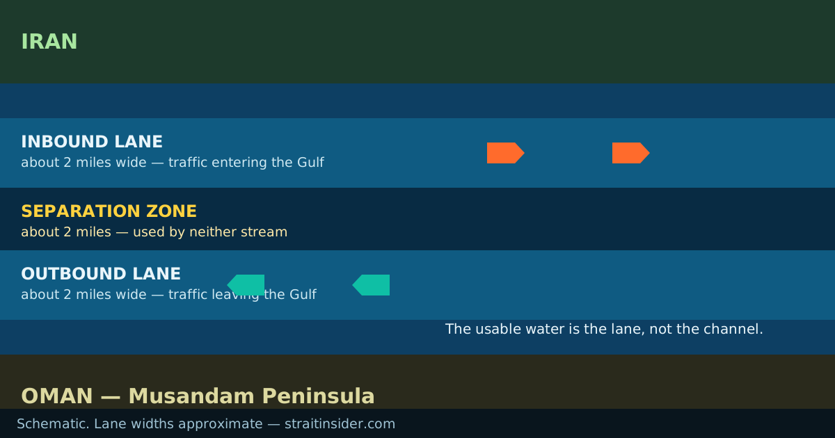
Traffic runs in an IMO-adopted traffic separation scheme north of the Musandam Peninsula: an inbound lane two nautical miles wide, an outbound lane two nautical miles wide, and a separation zone of about two nautical miles keeping them apart. Around six nautical miles of the strait therefore carries essentially all of the deep-draught traffic.
That is the number to have in mind when anyone discusses closing or defending the strait. Covering 39 km of water is a serious military problem; covering a six-nautical-mile corridor that every large tanker must use is a much smaller one. What a closure attempt actually looked like in 2026 bears that out.
Strait of Hormuz dimensions and size in full
The full set of Strait of Hormuz dimensions, for anyone who needs the size of the waterway rather than one figure from it: 167 km long, 39 km across at the narrowest and about 95 km at the widest, with a routed shipping corridor roughly 11 km — six nautical miles — wide. In nautical units that is 90 by 21 at the narrows.
The strait runs about 167 km — 90 nautical miles, 104 statute miles — from the Persian Gulf end to the Gulf of Oman end. A ship making 14 knots covers that in roughly six and a half hours, which is why transit is usually discussed in hours rather than days.
Depth is the dimension least well documented in general reference sources, and it has a page of its own because the honest answer involves more qualification than a single number allows. The short version: the channel is comfortably deep enough for the largest crude carriers afloat, and the areas that are not deep enough are precisely why the lanes sit where they do.
Common questions
- How wide is the Strait of Hormuz in miles?
- 24 statute miles at the narrowest point, which is 21 nautical miles or 39 kilometres. It widens to about 60 statute miles.
- What is the width of the Strait of Hormuz?
- The width of the Strait of Hormuz is 39 km — 21 nautical miles — at the narrowest point, and about 95 km at its widest. The Hormuz Strait width most often quoted is the narrowest figure.
- What is the length of the Strait of Hormuz?
- The length of the Strait of Hormuz is 167 km, which is 90 nautical miles or 104 statute miles. Hormuz Strait length and width together give 167 km by 39 km at the narrows.
- How wide is the Strait of Hormuz in kilometres?
- 39 km at the narrowest point, widening to roughly 95 km. Some sources give 50 to 55 km for the narrowest point, measured between different reference points.
- How long is the Strait of Hormuz?
- 167 km, which is 90 nautical miles or 104 statute miles.
- What are the dimensions of the Strait of Hormuz?
- 167 km long, 39 km (21 nautical miles) wide at its narrowest and about 95 km at its widest, with a routed shipping corridor roughly 6 nautical miles across made up of two 2-nautical-mile lanes and a 2-nautical-mile separation zone.
- How wide are the shipping lanes in the Strait of Hormuz?
- Two nautical miles, or about 3.7 km, in each direction, with a separation zone of about the same width between them.
- Is the Strait of Hormuz the narrowest shipping chokepoint?
- No. Bab el-Mandeb narrows to about 29 km and the Bosphorus to under a kilometre. Hormuz is the most consequential rather than the narrowest, because of the volume that passes and the absence of any alternative. The comparison with Bab el-Mandeb is here.